how-to: backcountry route planning - part II, during and after the trip
Welcome to the second part of my series on backcountry route planning, where we’re learning tools to plan our own backcountry trips. In the first part of this series, we reviewed how to use Caltopo to plan your trip and how to download your notes and maps to Gaia GPS for use in the field.
In this week’s installment, we’ll cover the in-field and post-trip aspects of backcountry trip planning, including:
taking notes in the field
transferring paper notes to Caltopo after your trip
transferring notes from Gaia GPS to Caltopo using the Gaia GPS web app
Note: screenshots and pricing information are current May 2019
taking notes in the field

Andrew Skurka’s guide-maps on the Wind River high-route. the author does an excellent job of noting critical navigation features and calling out hazards
As I travel through the backcountry I’ll often take notes on the terrain I’m passing through to reference later in the trip, when planning future trips, or when sharing the route with friends.
some examples of noteworthy information
specific, accurate information to use when reversing the route (location of snow-bridges or an easy downclimb)
navigable passes to be used when connecting basins
great campsites you’ll want to reference later
an especially sweet skinny dipping spot
On a recent hut skiing trip to the Wallowa Mountains of NE Oregon, I took note of the location of the camp and the fun ski lines surrounding it:

notes taken on a recent hut-skiing trip
transferring paper notes to Caltopo
In Part I we covered reasons for using Caltopo as your main trip planning tool. Those same reasons make it a great place to save all your trip notes. The following shows a selection of my past and future trips, saved in Caltopo for easy access:
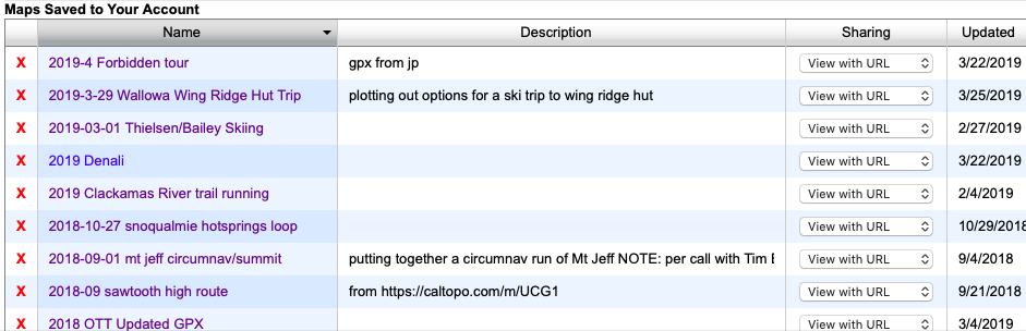
trip history and plans in Caltopo - this makes for easy future reference and sharing
Once back at home, I opened the map I’d used to plan the Wallowa trip by clicking it in the trip history shown above. Then, I added the notes I’d taken to it using markers and lines:

hut-skiing trip notes added to Caltopo, click the map to view an interactive version
transfer notes from Gaia GPS to Caltopo using the Gaia GPS Web App
In addition to my paper notes, I dropped pins in Gaia to record noteworthy features when I didn’t have a pen handy or didn’t feel like pulling out a map. To get those notes into Caltopo I used the following process.
navigate to the Gaia GPS website and login using your account
navigate to your saved waypoints

3. file your waypoints in a folder
select waypoints
click ‘File to Folder’
select folder or create a new one
once filed, click the folder name to open it

4. export the folder as GPX file for use in other apps or devices (GPS for example)

5. import your GPX file to Caltopo
NOTE: Due to a bug, Safari sometimes adds the extension ‘.xml’ to GPX files. If this happens delete the ‘.xml’ your file should end in ‘.gpx’
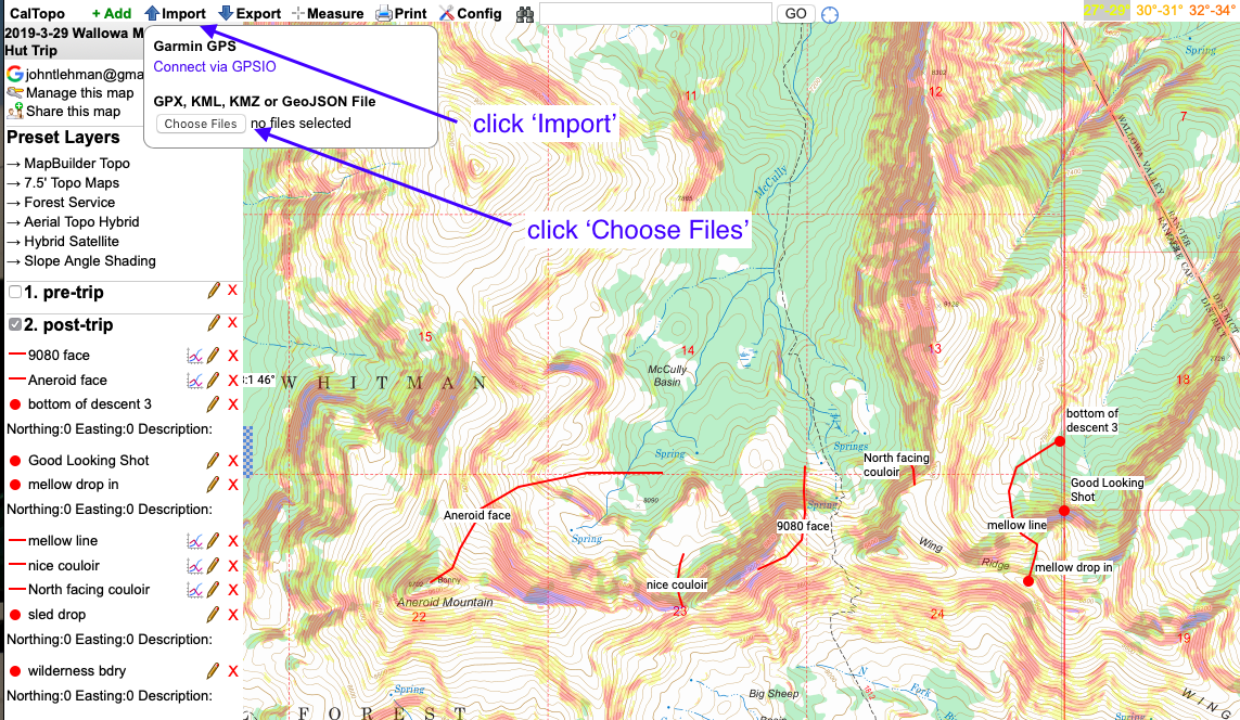
6. Select markers for import

Once you click ‘Import’ the notes you’ve created in Gaia will be visible in Caltopo, and you can save them to your map for future use.
If you’ve been keeping up with the series so far, you’re now ready to create your own maps (see part I), record notes in the field, and transfer trip notes back to your trip history in Caltopo. If you have any questions or additions, shoot me a note using the contact page or add a comment below.
In the last installment of this series, I’ll post a summary of some favorite backcountry planning and navigation tools, including some tools we haven’t seen yet. See you next week!